Kia Ora everybody, today in our Hurumanu 3 class our teacher needed us to compose a clarification expounding on the Polynesian navigators, and how would they do that. So when we do this we need to pick if were advanced with regards to composing stuff,I picked advanced and my responsibility is to initially compose my presentation about the subject, and after ward in section 2 I need to compose facts about navigation in space, passage 3 the Polynesian Navigation. Finally the end. I need to recall to in any event compose 6-7 sentences in each section.
Before we compose our unique composition, we need to let out mate read our work and let them gave me a criticism. Also, when I have my input, I can naturally change my blunders like my syntaxes/grammars, spellings, and so forth I had a great time learning this thing on science, since I don't think a lot about it. It was hard toward the start since we need to surge, since this is our last day of composing this.
What am I explaining? Well I’m explaining to you what is navigation, have you ever used the stars to navigate?
Also have you ever known that the Polynesian navigate the stars while on their boat.
Do you ever know the steps? Why do they do that?
Navigation is also the other definition of GPS, this is just an example of navigation( it means following a route ) Starting off with navigating the stars, so what I am saying is that when you are lost you can use the stars but the only thing is that you should know where the North and the South are. Navigating is really important for you to learn, because when you get lost in the sea you can easily find your way home if you know the steps. The only thing is that there’s a lot of steps and instructions that you should learn before you get lost.I have a lot of reasonable evidence to suggest why you need to listen to this writing of mine.
The space navigators are all used to do techniques by just using the sea and the air, but then suddenly they created a new science space navigation. That invention used stars sighting, precise timing, and even radio communications. In addition a lot of people actually used the stars to navigate, these people were the Polynesian when they were travelling across the vast sea. Therefore in the sea there is no wife signal to contact someone. Because they are in the middle of the deep blue ocean/sea .Moreover, the Polynesian people navigated the star a thousand years ago, that’s why they have a plethora of knowledge. That maybe all of them learned from their leader/master of the community.
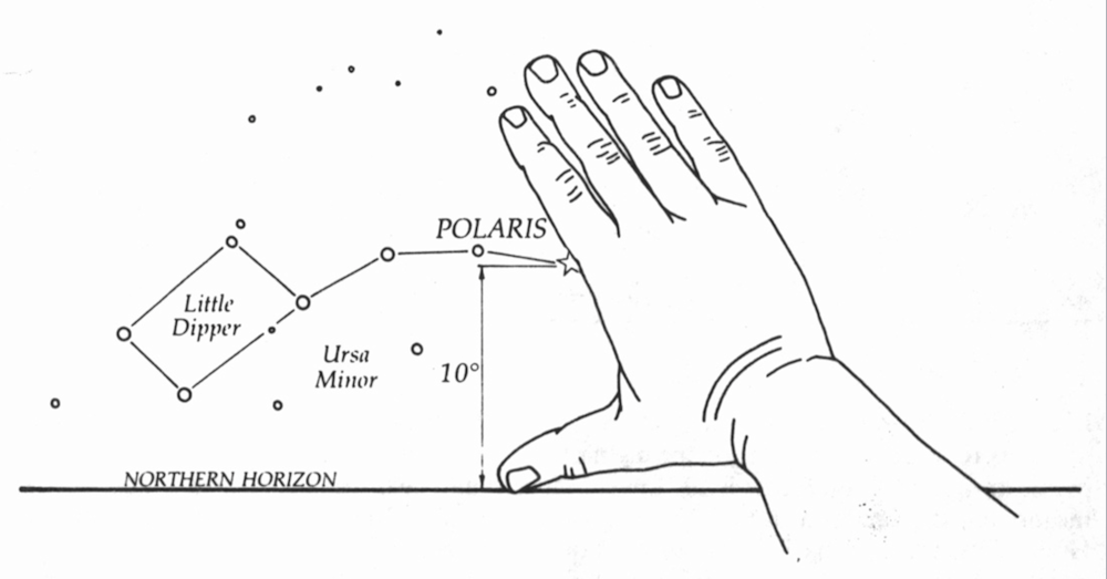
Polynesian navigation is actually hard to follow because there’s a lot of steps, and knowledge that we all need to know. Furthermore, if you want to learn how to navigate stars then you must know the Northern Hemisphere, and the Southern hemisphere. The very first thing you should know, is to learn your constellations well. This is a group of stars that would create a difference of patterns in the sky. These stars sometimes shift in the sky, and will be only visible depending on the season. There’s this constellation called circumpolar, this was visible all year long. It never rises or sets, knowing this constellation will make your life easier and will help you more because this allows every navigator to find their way home using this. Primary constellations that were located in the Northern Hemisphere and Southern Hemisphere. The Ursa Major also known as the big dipper, was found in the Northern Hemisphere, this thing shapes like a big bear. This sometimes was called a saucepan, it can easily be spotted in the northern sky. It will also help you how to locate the North Star. Ursa minor(little dipper), the small version of the big dipper. It can be really helpful because the North Star will always be the last star on the Little dipper’s handle.
Cassiopeia is a group of brightful five stars,and when you look in the sky you will see it as the shape of W. Can also be used to find the North Star when Ursa major isn’t visible in the sky. Orion a three bright stars, it was a recognisable constellation of the Northern Hemisphere. This has guided the navigators for decades. Now let’s talk about the Southern Hemisphere constellation. Crux also known as the Southern Cross, this is actually the most important constellation of navigating. It symbolises the five stars that form like a cross, and guess what it was the smallest constellation in the space. Centaurus, the opposite of the Southern cross, resembles like the Greek mythology, and the Southern Cross constellation is useful to identify more of the south. Now let’s find out how to find the Southern Cross constellation, since we're in the south not in the north.And the North Star is only visible at the northern hemisphere, and we wouldn’t be able to find that easily. Although this constellation is not as bright like the others, and this can be seen year-around at every seconds of hour in the night. And no matter what time of year it is,the Southern Cross always reaches its highest point in the starry night only when it’s pointed due south. You’ll see this stand perfectly at the very upright of the horizon, with its long part of the cross pointing straight towards the south pole. Still there are some more steps to follow, so you need to draw a line at the very top star of the Southern Cross( Gacrux), and then of course to the bottom star of the cross ( Acrux ).
Did you know that the Centaurus is located next to the Southern Cross, and to remember it has two bright pointer stars that create the front leg of Centaur. These two pointers are known as Alpha Centauri and Beta Centauri. Once we found out the Southern hemisphere and Northern hemisphere we need to locate the East and the West. It’s really easy. All you need to do is to streak your arms out straight to the both sides. So when you are facing the north, your left arm points west and the other point at the north. Then when you are facing the south, your left arm is pointing in the north direction, and the other side points in the west. Orion also helps the navigators to find the east and the west because it rises in the east and sets in the west.
Now we need to know how to determine your latitude and longitude, since where in the south hemisphere. I will tell you the methods that were also the same as the north one, all you need to do is find the Southern Cross and Centaurus. Then you need to measure the distance between the south pole, and the horizon with your fist. This is very helpful because you don’t need to use charts or any tools. The navigators also need to know their longitude, and let me tell you that this can be hard because they have to be careful about record-keeping, but early days for them when they are navigating the expanses of waters. All they do is to track the movement of the rises and the state of the stars across the sky. Record every specific position of the rise and set that every star in the night, at the same exact time. That’s how the early navigators know their longitude and latitude.

The ancient Polynesian used the sun, moon, stars, clouds, planets. To guide them,and to find their location. These voyagers relied on their Wa’ Kaulua or also known in English as the double-hulled canoes, they were powered by sails and steered including a single large oar. Navigators are built to be familiar with the trade wind-generated ocean swells that flow in southeast or northwest. That helped them to identify the directions by the rocking emotions their boat is showing caused by the swells, Furthermore the sunrise and the sunset is really useful to them, because the sun indicate the east and the west, but the problem was when it created a low light on the ocean that made it possible to see the swells directly. They even also used a thing called a star compass. These people remember the points of stars and constellations, even when they are visible and different times of years. They used them to divide the sky into four parts, while their boat is the middle.
Example, when they saw a star rising they already knew that to be the Northeast. So when the Earth axis points toward the North Star, and that always indicates north. This isn’t visible in the south, so they used the Southern Cross.All you need to do is to draw a line to the first top stars and connect it to its opposite side, but then you also need to extend it 4.5 times and draw a line from there horizon. That's how they know where the south is.
So this is how the navigators know their path by utilising the stars, moon, planets. Or then again even the move of the sea. Interestingly, you have to have a ton of information about the constellations, and such things. The Polynesian were the ones who knew a ton about this,because they sail a large number of kilometres by looking at the sky.
No comments:
Post a Comment
To support my learning I ask you to comment as follows:
1. Something positive - something you like about what I have shared.
2. Thoughtful - A sentence to let us know you actually read/watched or listened to what I had to say
3. Something helpful - how have you connected with my learning? Give me some ideas for next time or ask me a question.